If you`re on the hunt for a map of Memphis then you won`t have to look much further, since there are some right down below. Memphis is the 20th largest city in the United States, and the largest in the state of Tennessee. It has a population of 646,889, as of 2010. The city lies near the states of Mississippi and Arkansas, and its metropolitan area includes counties lying across the border in those states. That metro area has a population of around 1.3 million. The city itself is largest than Nashville Tennessee, but Nashville`s metro area as a whole is actually bigger than Memphis`s.
The city is situated just south of the place where the Wolf River and Mississippi River meet. It has a humid subtropical climate, with hot humid summers with thunderstorms, mild to cool winters with very occasional snowfall, and fall and spring are quite pleasant.
FUN FACT: Memphis Tennessee is named after Memphis, Egypt - the ancient capital near what is today known as Cairo.
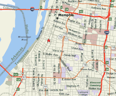
Here`s a map showing all the major roads in Memphis. Click on the map to be able to zoom and download.
This next Memphis map here is an overview of Memphis and the surrounding areas.

This final map shows Memphis and all the highway interstates in the vicinity. If you`re driving in from out of town, then make sure to check out your route in advance. Don`t rely on GPS!

Up above you could choose a map of Memphis TN from several choices. Hopefully one of them suited your needs.
The city is situated just south of the place where the Wolf River and Mississippi River meet. It has a humid subtropical climate, with hot humid summers with thunderstorms, mild to cool winters with very occasional snowfall, and fall and spring are quite pleasant.
FUN FACT: Memphis Tennessee is named after Memphis, Egypt - the ancient capital near what is today known as Cairo.
Here`s a map showing all the major roads in Memphis. Click on the map to be able to zoom and download.

This next Memphis map here is an overview of Memphis and the surrounding areas.

This final map shows Memphis and all the highway interstates in the vicinity. If you`re driving in from out of town, then make sure to check out your route in advance. Don`t rely on GPS!

Up above you could choose a map of Memphis TN from several choices. Hopefully one of them suited your needs.


0 Comments